|
Northern Ohio Railfan
Home Berea to Oak
Harbor Oak Harbor West
Berea to Greenwich Vermillion to Bellevue
Favorite Links
|
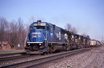
| Berea is where we start. The parking lot is gone but there are still
some places to shoot from. It can get crowded on weekends. The Pufferbelly parking lot is good for trains coming and going from the Short
Line. The blue star indicates the Berea tower. Here are some pictures. I've also listed a small map with some key
spots indicated, and I've provided a brief written description of each area
At this point, I should mention the Ohio Gazetteer by Delorme. It shows
all the roads that I mention. Also there is a county atlas put out by
Commercial Survey Company for Cuyahoga, Lorain-Medina and Erie-Huron
counties. It is excellent, and it's easily recognized by it's red cover
It costs only $5 and is available
everywhere.
|
 |
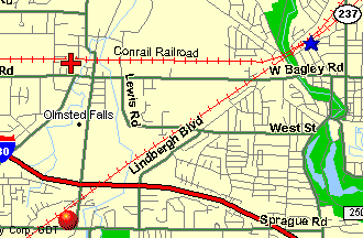 |
| Olmsted Falls |
About two miles west of Berea just off of
Bagley road on Garfield street is an old depot at milepost 196. The depot
is the home of a model railroad club. There is a Pennsy caboose parked in
the yard. It is a good place to park and take pictures except in the winter
there are pole shadows. The red cross shows the location of the old depot on
Garfield street. From here go back to Bagley and go east 1/8th of a mile to
Columbia and turn right. Go south one mile to where the Columbus line
crosses Columbia Road. This is marked by the red dot.
|
| |
|
 |
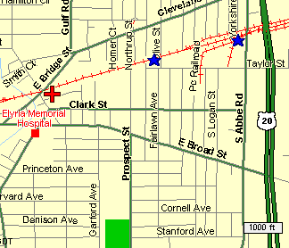 |
| Elyria |
|
The Amtrak station in downtown Elyria is an excellent spot. There is plenty of parking.
It is on the corner of East Bridge Street and
East River Road. You can hear westbounds at the Olmsted detector about 6
miles to the east. There are two other spots in Elyria, Olive Street
crossing and Abbe Road crossing where you can watch westbound trains working
the small yard. The red cross is the Amtrak station, the blue stars are the
other 2 locations.
|
 |
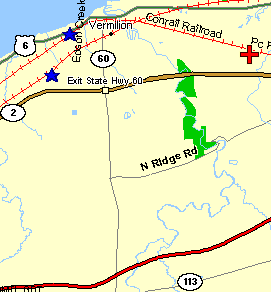 |
| Vermilion |
Downtown Vermilion is great with a small park
and plenty of parking. This is MP 220.9 right at the detector. Good for westbounds and eastbounds. From there, go East on Rt 6 about 3 miles to
Sunnyside road. Turn right, then go south one mile to the tracks. Best for
PM westbounds. A lot of trains stop at Fairlane just to the east. Park on
the southside at a safe distance from the tracks. Trains can be moving very
fast through here. The red cross represents the Sunnyside NS crossing. Get
back on Route 6 and go west through Vermilion to Coen Rd about 1 mile west
of downtown, turn left and cross the tracks. You can park just south of the
tracks. Best for eastbounds in the morning. Amtrak #44 comes through about
11:30 am. Just south on Coen Road, NS crosses. This is where the new
connection has been installed. It is for eastbounds from NS to ex-CR or
westbounds from ex-CR to NS. This spot is best for eastbounds in the am. There is a detector 7 miles west and one 11 miles to the east. Referring to
the map, the new connection is between the two blue stars.
|
 |
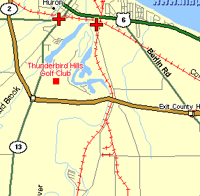 |
| Huron |
At mile post 232, Huron has two good spots.
Number 1 is at river road. Summer early AM eastbound shots can use the
signal for a prop. Number 2 is at Rte 13 on Main Street. Good all day long.
Best in PM to work signal bridge into shot. Park in the convenience market
lot. The donut shop at Rte 2 and main street has excellent muffins, but they
close at noon. Huron has an elevator complex which has 2 switchers and 1
stored. This is served by NS daily. This track runs under the NS main line
at River road. There is also an ore dock next to the elevator this is served
by W&LE. The Wheeling usually shows up in the morning with 50-60 empties and
takes all day to be loaded by a front end loader. Best time is pm. When you
are done, drive south on River road following the Huron branch about 2 miles
to Knight Rd, left on Knight to 2nd road Jeffries, turn right on Jeffries,
south 1 mile to the NS at a place called Shinrock siding.
|
 |
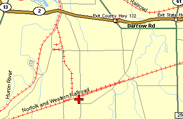 |
| Shinrock |
The red dot indicates Shinrock siding.
This is where the Wheeling gets on the Huron branch. They pull into the
siding from the west, then run around the train to recouple and head north
to Huron. Since the units are usually coupled back to back, you can get 2
sets of shots. The Wheeling symbols are 340/341. From here you can follow
the NS into Bellevue or go back up to NS Chicago line
|
 |
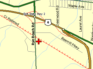 |
| Rye Beach Road |
Back in Huron we head west on
Route 6 to Rye Beach Rd. Turn left, go south to tracks. A good place for Eastbounds with the signal for a prop. From here you can follow the tracks
on Route 6 or take the bypass all the way around Sandusky to Route 101 exit
at 101 and turn right. Go northeast on 101 to Superior turn left. 1/2 mile
to Venice Rd, rt6, Turn right on Venice go 1/4 mile, turn left on Huron just
before NS tracks. Go north to Conrail main.
|
 |
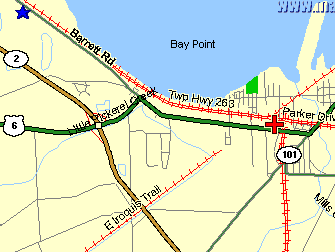 |
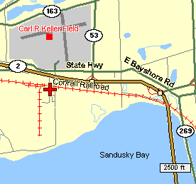
| Sandusky |
We are now at CP 242. The red cross shows this
location. A good spot to sit all day. The Sandusky detector is at MP 239, 3
miles to the east. The Gypsum detector is at MP 251, 9 miles to the
west. Here NS runs transfers from the coal dock to their Sandusky yard. They have to call the NS Toledo East dispatcher to get across. Normal power
is SD9's. To the east is NS's Sandusky yard and the Amtrak station. The
station is on the north side of the tracks and is tough to work into a
picture because the yard is usually full and cars are in the way. A single
GP-38 works the yard. Leaving CP 242, go back to Venice road and head west
following the tracks. You will end up on Barrett road which is right along
side the tracks. At MP 244 to MP 246, there is water between the road and
the tracks. Some shots can be taken from here. The blue star shows this
location. Follow Barrett into Bayview, go south on Rte 269 to Rte 2, turn
right, go west across the Bay bridge. Exit on Rte 53, go to the first
light, turn left on State road and go west 1/2 mile to Lake road. Turn
left and go south to the tracks.
|
 |
 |
| Gypsum |
There is good parking here right at the signal
and the Gypsum detector. The red cross indicates the location of the Gypsum
detector. Retrace your steps and get back on Rte 6 west and go around Port
Clinton because there aren't any decent shots in Port Clinton because the
tracks are elevated. Cross the river and get off at Rte 163, turn left and
go west to Oak Harbor. Turn right on Rte 19 and go north to the tracks
|
 |
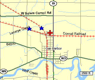 |
| Oak Harbor |
There is an old depot here that is now used by
M of W people. To the west the NS line from Toledo to Bellvue crosses
overhead. There is a lot more traffic on this line now that the connector
track is in. Trains coming east off the ex-Conrail line going south to
Bellevue. Trains coming north from Bellevue going west to Toledo on the
ex-CR main. Here you are between the La Carne detector at MP 260.9 to the
east and the Graytown detector at MP 272.9 to the west. Nice shot in
midsummer am for east bounds coming around the curve under the NS bridge.
Just to the west is the new connector from CR to NS. The new connector is
between the blue stars. The red cross is the place for EB shots.
|
| |
|